


Italy weather forecast
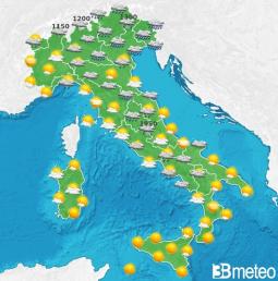
The situation. According to the weather forecast, as the hours pass, this disturbance will also move towards the east and clearings will take over from the west, but on Thursday a new and rapid unstable impulse transported by the southwestern carrying currents, it will trigger a temporary resumption of the phenomena, especially on the Tyrrhenian side and in part of Northern Italy.
Nord: Rain and thunderstorms extending from the Ligurian East to Lombardy and Triveneto, but improving in the afternoon from the west. Snow from 1200m. Temperatures rising, maximum between 13 and 17.
Center: Rain and showers in Tuscany, Umbria and inland areas, easing from the afternoon with clear spells. Snow in the Apennines from 1300m, rising. Temperatures rising, maximums between 15 and 19.
Sud: Clouds and showers on the Tyrrhenian peninsular regions in the morning, then it improves, more sun elsewhere. Temperatures dropping. Highs between 17 and 21.
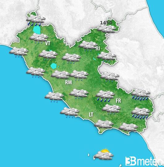
Lazio weather evolution
THURSDAY': humid infiltrations reach the Region causing many clouds with mostly cloudy or very cloudy skies, but without noteworthy phenomena. In particular on the northern coasts very cloudy or overcast skies with partial openings during the second part of the day; on southern coasts e capital very cloudy or overcast skies with a tendency to clear in the evening; on the northern plains very cloudy skies in the morning with light rain, absorbing during the afternoon; on the southern plains e sub-Apennines very cloudy or overcast skies with light rain, absorbed by the evening; on the Apennines Very cloudy or overcast skies throughout the day, with some showers in the afternoon. Moderate southerly winds rotating in the south-western quadrants; Thermal zero around 2100 meters. Very rough sea.
Comment from the forecaster Medio Tirreno
UNSTABLE AND DISTURBED AT TIMES – IT IMPROVES TOWARDS THE WEEKEND WITH SIGNIFICANTLY RISING TEMPERATURES – On Wednesday, a new frontal passage from the west, this time followed by colder air which will also lead to a drop in the snow level with a few flakes around 1300/1400 meters at the end of the event. Residual rain on Thursday, in particular towards upper Tuscany where it may be locally more intense. More stable weather towards the Easter weekend with temperatures rising sharply due to the influx of hot air from the south which will cause the maximum values locally to exceed 23/25 degrees. There remains some uncertainty about the expected weather for Easter Monday when there could be greater instability with temperatures gradually decreasing in the following days.
Fonte: 3B Meteo
ilfaroonline.it it's on GOOGLE NEWS. To always be updated on our news, click on this link and select the star at the top right to follow the source.


